Posts

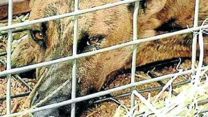
Wild dog pests in their sights

Increased levels of damage to livestock have meant pest animal groups are targeting wild dogs as a priority across the region.

There are five pest groups within the Watershed Landcare area, these being the Hargraves Hill End Wild Dog Group, Ilford Running Stream Pest Group, Rylstone District Wild Dog Association, Munghorn Wild Dog Group and the newly formed Piambong Yarrabin Pest Group. These groups are volunteer run and strive to support landholders and residents within their areas to manage wild dogs and other pest animals.

The Groups, and the Mudgee LLS, are the first point of call if landholders have seen wild dogs or suspect they are suffering from livestock attack or losses.

“Communication and reporting are vital.” said Peter Sipek, Chairman of the Munghorn Wild Dog Group.

“We all need to know if our neighbours have seen dogs or they are having problems on their place. If we know where they are we can target our control much more effectively.” he continued.

Coordinated, winter 1080 baiting programs are currently being undertaken. “Again, we encourage all landholders to get involved,” said Peter “the greater the area we cover within a baiting program means fewer pockets where dogs can exist, and it takes longer for them to re-establish in the area. Wild dogs are a community problem and we need everybody to get on board.”

The Munghorn Wild Dog Group’s baiting program will be carried out on Thursday the 30 August and follows on from baiting programs recently carried out in the south and east of the region.

Remote cameras are used extensively across the region, providing a valuable tool pre and post baiting. If dogs continue to be seen on these cameras, or mauled livestock are reported after a landholder has been involved in a baiting program, then sending a trapper to the area can also be considered.

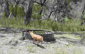
Wild dog detected on a remote camera in the upper Bylong area.

Contact details for the 5 pest groups are:

Hargraves Hill End Wild Dog Group: 0458 733 308

Ilford Running Stream Pest Group: 0427 025 802

Rylstone District Wild Dog Association: 6379 6256

Munghorn Wild Dog Group: 0417 322 436

Piambong Yarrabin Pest Group: 0438 686 369

Watershed Landcare Pest Animal Group Coordinator Beth Greenfield can be contacted for more information on 0438 090 525 or by email beth.greenfield@watershedlandcare.com.au.

Mobile phone App to map wild dogs

Wild dogs are not only a threat to native wildlife but also generate significant losses for primary producers; direct impacts such as killing and maiming stock, as well as the time and resources invested into control strategies, affect operational costs.

Landholders have a new tool available for use in their wild dog control toolkit, they can now access WildDogScan with their mobile phones to record wild dog data while in the field.

The new, easy to use website and Phone App (free for Apple and Android devices) was designed by landholders and enables iPhone, Android and iPad users to record sightings using their mobile phone. It also allows users to examine wild dog data throughout their local area.
Watershed Landcare spoke to FeralScan Project Coordinator, Peter West, to find out how landholders can utilise the new resource to aid in wild dog management.

“We are trying to encourage people to document wild dog activity in their local area and over time see a regional picture emerge in regards to wild dog movement, behaviour and timing of problems.” said Mr West.

“Wild dog research suggests that there are patterns in activity and we are hoping that providing farmers with a tool to easily record wild dog activity will help them to build a picture of wild dog activity for their entire region, and that this helps all landholders in a region to improve wild dog management by reducing costs and increasing benefits.” he continued.

The WildDogScan Mobile Mapping Facility allows landholders to:

  • record wild dog sightings, their damage and control activities,
  • use the data from their local area to create and print a map,
  • identify the priority areas for control on their property and local area,
  • link with neighbours and local groups and coordinate resources,
  • monitor the effects of control programs and improve their effectiveness,
  • review the map to see changes over time,
  • inform their community about wild dog problems.

“An added benefit is that it will help landholders and biosecurity staff connect. Key Local Land Services biosecurity staff can be notified of wild dog activity as it is recorded to keep everyone in the picture about current wild dog problems.” said Mr West.

Visit www.feralscan.org.au with your mobile phone or download the free FeralScan App to get full use out of the WildDogScan mapping service.
Landholders who would like more information about WildDogScan can contact Peter West on 6391 3887 or by email peter.west@dpi.nsw.gov.au, or contact the NSW Local Land Services.