Keep an eye out for swarms

The bees have been busy this spring, with a large number of swarms appearing across our district they have also been keeping members of the Mudgee Bee Group busy.

“Mudgee has been the hot spot this spring; the Mudgee Bee Group has collected at least 8 swarms around town, as well as a couple at Gulgong.” said Mudgee Bee Group swarm co-ordinator, Sandi Munro.

“The public have alerted us to several swarms, via our Facebook page and through the Amateur Beekeepers Association swarm collectors list.” she continued.

The Mudgee Bee Group removing a large swarm from a grapefruit tree in Gulgong.

Swarming is the way bees increase their population. Swarms can be spectacular when you see them flying over and settling to rest somewhere. Usually bees are at their calmest when swarming, but not always!

“Swarms are exciting to see, and usually easy to remove, from a branch or letter box, but if they move into your chimney or eaves of the house, they are a lot more difficult to remove, so let us know as soon as you spot them, the sooner the better!” said Ms Munro.

Mudgee Bee Group have a swarm co-ordinator that can assist with information or removal of a swarm, contact Sandi Munro on 0487 898 404.

Spring is when the bees do their most important work; pollinating trees, crops and flowers and, of course, making honey!

To help the bees this spring there are a few things you can do.

Bees use up to 5 litres of water a day per hive during hot weather to quench their thirst, and to keep the hive at a constant temperature for the brood to be healthy. In dry times you can help by putting water out for them. Bees can’t swim, so add some sticks, pebbles or corks to the bird bath to help them get out if they fall in.

Don’t use chemical sprays, especially on blooms. Spraying blooming flowers, trees, shrubs and lawns can kill bees! Even some deemed safe for humans are detrimental to bees. Even ‘safe’ sprays leave a residue that is picked up by bees in both nectar and pollen and can then end up in your honey.

Plant a bee garden – bees need food and most flowering plants give some benefit to bees by way of pollen and nectar. Borage, lavender and rosemary are easy to grow and very popular with bees. Annuals, perennials, trees and shrubs can all be planted to benefit bees.

If you would like to learn more about bees, come along to a Mudgee Bee Group meeting or find us on Facebook (www.facebook.com/Mudgeebeegroup). For more information contact Claudia Wythes, Watershed Landcare Coordinator, on 0412 011 064 or claudiawythes@watershedlandcare.com.au.

The Mudgee Bee Group is supported by Watershed Landcare and the Amateur Beekeepers Association and is a part of the NSW Government’s Local Landcare Coordinators Initiative, supported through the partnership of Local Land Services and Landcare NSW.

Keep rain on your farm for longer

Australian is a land of climatic extremes. Farmers and land managers contend with cycles of flood and drought punctuated by the odd ‘good’ year. While we rarely complain about there being too much water, we do spend a lot of time wishing for rain.

But what if you could capture that water and keep it in the landscape, and on your farm, for longer?

Watershed Landcare will be hosting a Rehydrating the Landscape workshop in November.

The workshop will be presented by Dan and Nicki Power who have constructed a system of dams and swales on their farm to rehydrate the landscape, and regenerate degraded soils and create an edible landscape at the same time.

Dan and Nicki will discuss what our farms would look like if they were rehydrated, what influence we have as land managers in the amount of water that stays on our farm, and what interventions we can make, from small to large, to increase our influence.

They will cover the principles of rehydrating the landscape as well as showing examples of successful rehydration interventions.

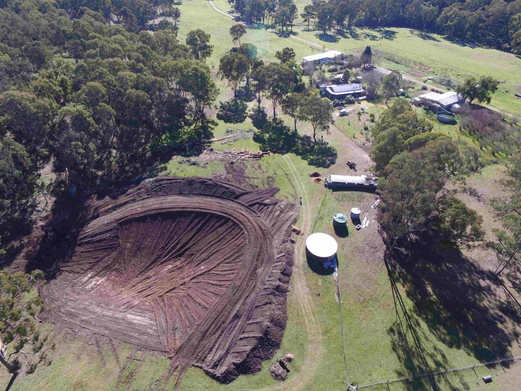
Sign of things to come: Construction of a dam which, together with a system of swales, will rehydrate the landscape.

We will also go for a walk around the farm to see what’s been achieved, the particular issues faced and discuss the next steps. Adon Bender, the farm rehydration adviser, and Mark Anderson, the dam builder, will also be on hand to provide explanations and answer questions.

The workshop will be held on on Saturday, 4 November from 9am to 4pm at Hazelcombe Farm, Totnes Valley (40 mins from Mudgee). Attendance is free for Watershed Landcare members and $10 for non-members. Please wear work clothes and covered footwear and bring hats, sunscreen and drinking water.

For further information or to RSVP contact Agness Knapik, Watershed Landcare Coordinator, on 0435 055 493 or by email: info@watershedlandcare.com.au.

This event is supported by Watershed Landcare and is a part of the NSW Government’s Local Landcare Coordinators Initiative, supported through the partnership of Local Land Services and Landcare NSW.
Got a bushfire plan for your property?

With the recent rain experienced in our district the immediacy of bushfire risk has passed. But if you’d had a fire at your place would you have been prepared?

This year saw a late but active fire season in our region with a number of severe events experienced, such as the Sir Ivan fire. With more than 55,000 ha burnt the property and stock losses were devastating. However, no human lives were lost and this has been put down to people having, and acting on, their bushfire plans.

Do you know who your local Rural Fire Service (RFS) brigade is? Have you got a plan for you family, pets and livestock in the event of a fire? Are you adequately insured? Are your business records backed up off-site?

There’s a lot to consider in the preparation of a bushfire plan and it may seem daunting, so Watershed Landcare will be hosting a workshop next Thursday to help you work through the process.

The Bushfire Planning workshop will be held on Thursday 30 March in the Lecture Room, Small Pavilion, Australian Rural Education Centre (Opposite the AREC office). We will commence at 9:30am and aim to finish by 12:30pm.

We have invited Jayne Leary from the RFS to facilitate the workshop and walk us through the planning process.

We will also be joined by Brett Littler (Livestock Officer) and Nigel Gillan (District Vet) from Central Tablelands LLS who will discuss considerations for livestock in bushfire planning. They will also share their experiences from the recent Sir Ivan fire. Nigel will also cover companion animals.

This will be a hands-on workshop with plenty of opportunity to ask questions and bounce ideas off others. The intention is that you will walk away with a bushfire plan for your property, or at least a draft.

The workshop is free and everyone is welcome, you don’t have to be a member. So please bring along your family and tell your friends and neighbours.

If you would like to attend please RSVP by Monday 27 March. For more information or to register your interest please contact Agness Knapik, Watershed Landcare Coordinator, on 0435 055 493 or by email: info@watershedlandcare.com.au.

This event is supported by Watershed Landcare and is a part of the NSW Government’s Local Landcare Coordinators Initiative, supported through the partnership of Local Land Services and Landcare NSW. Watershed Landcare would like to acknowledge support from AREC.

Digging deeper into soil care management

Agro-ecologist, David Hardwick, will be working with local landholders to improve the soil health on their patch. Watershed Landcare have collaborated with Mr Hardwick on a number of soil health projects in the past and have invited him back for the Digging Deeper into Watershed Soils project.

The participating landholders will have their soil tested and work with Mr Hardwick to analyse the soil test results and determine management options.

The landholders will have the opportunity to increase their knowledge of the aspects which impact on soil health, such as soil chemistry, soil biology and ecology, and discuss their proposed on-ground works with Mr Hardwick to find solutions which are relevant to their operation, management approach and location.

Interested to see what they come up with? Watershed Landcare will be hosting a field trip to visit the participating properties in May.

David Hardwick will join us on the bus trip from Mudgee to visit the 3 farms and discuss the soil test results, work conducted and how the decisions were arrived at.

The discussion during the field day will also focus on soil biology, soil water, soil acidity and other soil health issues within our region more generally.

For more information on the Digging Deeper into Watershed Soils project or to register your interest for the field trip contact Bethany Greenfield, Project Coordinator, on 0438 090 525 by email: info@watershedlandcare.com.au.

This project is supported by Watershed Landcare through funding from Landcare Australia and the Jaramas Foundation and is a part of the NSW Government’s Local Landcare Coordinators Initiative, supported through the partnership of Local Land Services and Landcare NSW.

Mobile phone App to map wild dogs

Wild dogs are not only a threat to native wildlife but also generate significant losses for primary producers; direct impacts such as killing and maiming stock, as well as the time and resources invested into control strategies, affect operational costs.

Landholders have a new tool available for use in their wild dog control toolkit, they can now access WildDogScan with their mobile phones to record wild dog data while in the field.

The new, easy to use website and Phone App (free for Apple and Android devices) was designed by landholders and enables iPhone, Android and iPad users to record sightings using their mobile phone. It also allows users to examine wild dog data throughout their local area.
Watershed Landcare spoke to FeralScan Project Coordinator, Peter West, to find out how landholders can utilise the new resource to aid in wild dog management.

“We are trying to encourage people to document wild dog activity in their local area and over time see a regional picture emerge in regards to wild dog movement, behaviour and timing of problems.” said Mr West.

“Wild dog research suggests that there are patterns in activity and we are hoping that providing farmers with a tool to easily record wild dog activity will help them to build a picture of wild dog activity for their entire region, and that this helps all landholders in a region to improve wild dog management by reducing costs and increasing benefits.” he continued.

The WildDogScan Mobile Mapping Facility allows landholders to:

  • record wild dog sightings, their damage and control activities,
  • use the data from their local area to create and print a map,
  • identify the priority areas for control on their property and local area,
  • link with neighbours and local groups and coordinate resources,
  • monitor the effects of control programs and improve their effectiveness,
  • review the map to see changes over time,
  • inform their community about wild dog problems.

“An added benefit is that it will help landholders and biosecurity staff connect. Key Local Land Services biosecurity staff can be notified of wild dog activity as it is recorded to keep everyone in the picture about current wild dog problems.” said Mr West.

Visit www.feralscan.org.au with your mobile phone or download the free FeralScan App to get full use out of the WildDogScan mapping service.
Landholders who would like more information about WildDogScan can contact Peter West on 6391 3887 or by email peter.west@dpi.nsw.gov.au, or contact the NSW Local Land Services.

Buzzing with Landcare

Are you interested in learning about bees, or perhaps having your own hive but don’t know where to start?

Read more